Monitoring and forecasting system of rainwater, snow melt and mud flood based on weather station Inspector Meteo
Main equipment of the system:
In order to monitor rainwater, snow melt and rainwater and mud flood it is necessary to install the following equipment:
1. Ultrasonic sensor for industrial use in a metal pipe. The metal pipe will be 50 or 100 mm in diameter with holes along the entire area of the pipe with protecting net at the bottom of the pipe. This construction will be fastened on the post’s supports and dowsed at a distance of 15 — 25 cm from the bottom. (depending on the minimum level of water in a river and on configuration of the bottom).
2. Meteorological station suitable for power supply connection 220 V or photovoltaic power supply.A basic set of sensory devices — wind speed and direction, precipitation detector, solar irradiation detector.
3. Controller for collection and processing of information from meteorological station sensory devices and from the ultrasonic sensor for the monitoring of the water level in the river.
General scheme of the monitoring system operation and of rainwater, snow melt and rainwater and mud flood forecasting based on meteorological station Inspector Meteo (Figure 1):
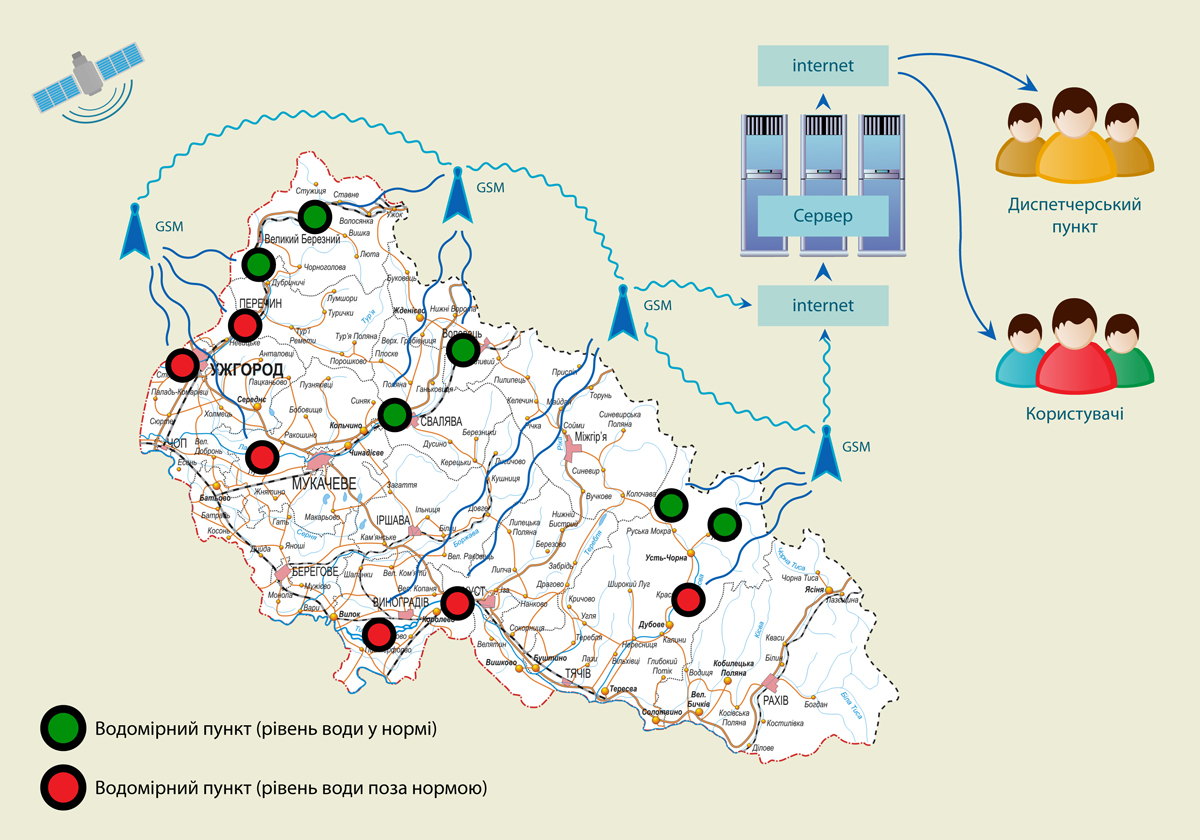
General scheme of the monitoring system operation and of rainwater, snow melt and rainwater and mud flood forecasting.
Figure 1.
System operating principle:
On the hydrographic or flood measuring post, there is installed the ultrasonic sensor in the metal pipe, which will take measurements of the water level with the specified periodicity, and deliver data to the controller for the collection of the information. The sensor will be built-in the metal pipe with holes and the protecting net at the end. It will perform a protection function from accumulation of mud and rubbish, sailing down the river.
Additionally to the controller, with the purpose of information collection, there will be entered the data from meteorological station sensory devices.
The data will be processed and sent to the central server, where in a real-time environment there will be possible to see the reports on water level and the meteorological environment in the given point.
The equipment can operate off mains power supplies 220 V or independently from the solar battery charge in the daytime, and from accumulator unit at night.
To the controller of collection and processing of data there may be connected the additional sensory devices as an option (water temperature sensory device, river flow speed sensing device etc.)
The frequency of data communication may be adjusted by means of the software or request from the device through the system.
Additionally, there may be connected to the system a weather forecasting service for the upcoming week for the particular point on the map. This service allows receiving the forecast indicating the number of precipitation in this particular region, wind speed and direction, atmospherical temperature, cloudage etc.
The system will work through the web-interface. The data from the controller on hydrological station or flood measuring post are available for every user with computer (laptop, tablet, cell phone) connected to the Internet under own login and password. There is a possibility of delimitation of access privileges.
The data can be seen both in graphic and table form within the specified period, unload to Excel table or XML file.
The data will be stored on the server for up to 3-years. There is available a review of the history within any selected period of time.
System’s look-and-feel (Figure 2,3,4):
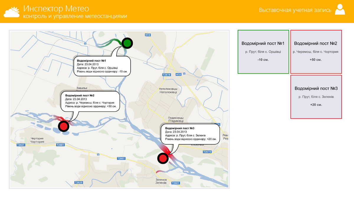
System’s look-and-feel (a map with indication of watermetering posts).
Figure 2.
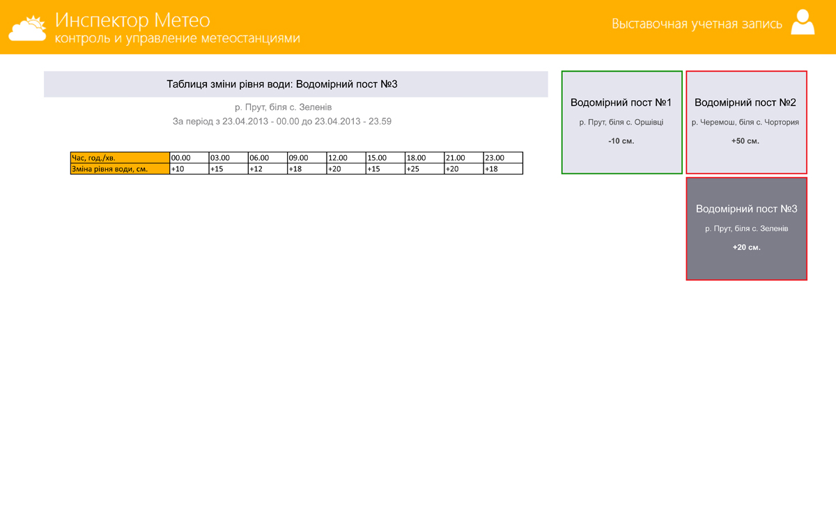
System’s look-and-feel (report in form of a table).
Figure 3.
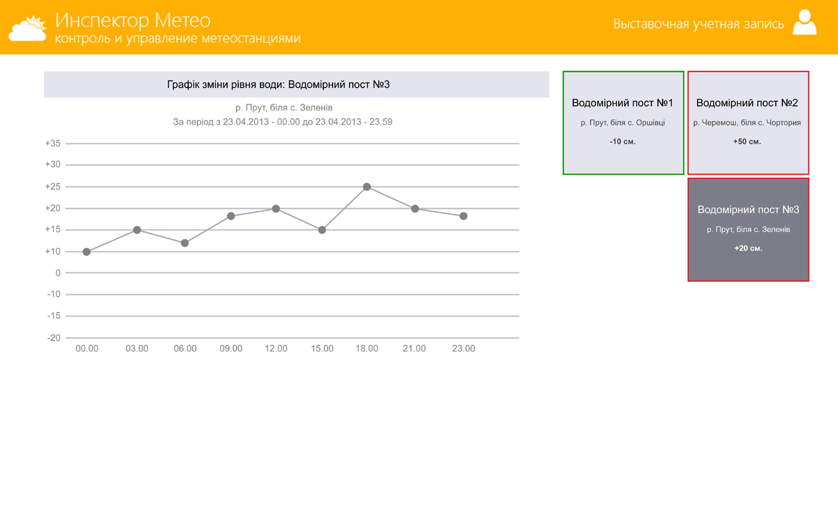
System’s look-and-feel (report in form of a graphic).
Figure 4.
Conclusions:
1. The system of monitoring and forecasting of rainwater, snow melt and rainwater and mud flood based on meteorological station Inspector Meteo will allow monitoring the level of water in the rivers in real-time mode.
2. Water level accuracy makes ± 2cm.
3. It is possible to review the information from any device connected to the Internet.
4. The adjustment of the alarm signal in a case of raising of water level in the rivers will allow speeding up the response on the part of appropriate services.
5. The system can be used for the forecasting of rainwater, snow melt and rainwater and mud flood in the rivers of Ukraine, Europe and CIS.